Gorgeous picture Fairy - such wide open spaces - I could wander around there for hours - bliss. The picture would make an interesting jigsaw too.Thanks for the link Pat E.
The island in my photo is Alderney - apparently Julie Andrews house is up for sale on that island and the bird is a Stonechat. The male has a black head and this is the female. I love the lichen on the granite too.
They're beautiful little birds GD. I love the lichens on rocks too. I took a pic on my way yesterday of a rock with a moss on it. I find all these things really interesting.
Yes - I was 'Mamore-ing' Joyce. I had planned to add on Binnein Beag to Sgurr Eilde Mor, which was my main focus, but it's a hell of a shift. You have to drop down such a long way into the corrie before going back up. I hadn't felt particularly well on Saturday, which is why I went yesterday. I'm glad I only did the one though as my knees were a bit iffy on the way back. I'll just have to schlepp back up another day to get the others
I'll organise my photos later. There were some nice ones. Nevis was completely clear, and you could see for miles.
It's a place where beautiful isn't enough of a word....
I live in west central Scotland - not where that photo is...
Yesterday's walk to Sgurr Eilde Mor - the most easterly of the Mamores, on the south side of Glen Nevis.
The fog en route stopped me getting any shots of Rannoch Moor, but five minutes further on, the fog was lifting and I got a quick pic of the two Black Mount hills (Meall a Bhuiridh and Creise) just before Glencoe.
Looking south over Loch Eilde with the Glencoe hills behind
Looking west over Loch Leven - the two Munros of the Ballachulish Horseshoe at the back. Pap of Glencoe sitting in front of them
Sgurr Eilde Mor and it's lochan - almost big enough to be a loch...
Looking north from the same spot. Binnean Beag centre of pic. Behind it - the Grey Corries on the right, the Aonachs on the left
Pano of Binnein Mor (left of pic) across ridge to Binnein Beag
Holidaymakers getting a clear shot of Nevis
From the summit ridge - looking down onto the lochan and across to Sgurr Mor Beag (which leads to Binnein Mor) with Na Gruagaichean just peeking up behind it
Ben Nevis and it's arete Carn Mor Dearg. The ridge from Binnein Mor to Binnein Beag in the foreground
From the summit looking south over the Glencoe and Orchy hills, B. Mor on right
Binnein Mor from the little arete on Sgurr Eilde Mor
Pano of S. Eilde Mor and lochan on way back
View up to Am Bodach - another of the Mamores - on the way back down
Hope you enjoyed my jaunt to the beautiful Kinlochleven Mamores
It's a place where beautiful isn't enough of a word....
I live in west central Scotland - not where that photo is...
It was about 9 and a half miles in total, but it's not quite the same as low level walking. Just under 7 hours, including all the stops. A little over 5 hours actual walking. It's about another 2 - 3 hours to add the other hill on.
Pretty vertical for the final ascent from the lochan and it's all eroded, loose scree, so you have to scramble up. In the third last pic, you can see where you get onto the ridge - from the right hand side, just beyond that pile of rocks at the bottom . The summit's about 100 feet the other way. Two steps forward and a slide back when you get near the top though, so I took a detour and went round the end and up over it instead to get up, which was good fun
It's a place where beautiful isn't enough of a word....
I live in west central Scotland - not where that photo is...
You're very kind ladies. Not that amazing when you get passed by all the younger, fitter people on the way.....
Veyr lucky with the weather. It wasperfect for walking - only a few degrees for the early part which makes it more pleasant, enough breeze to keep you cool but not too bad on the exposed bits. Clear skies so that you felt you could see forever. From the summit you feel that you can see almost every hill inthe Highlands and Cairngorms. Buzzards and bellowing stags. What more could a girl ask for
This chap had a pretty good view from the other end of the summit ridge too
It's a place where beautiful isn't enough of a word....
I live in west central Scotland - not where that photo is...
Posts
Memories Fairy. . . once had a boyfriend from Kinlochleven.
Glorious view Were you doing the Mamores?
Gorgeous picture Fairy - such wide open spaces - I could wander around there for hours - bliss. The picture would make an interesting jigsaw too.Thanks for the link Pat E.
The island in my photo is Alderney - apparently Julie Andrews house is up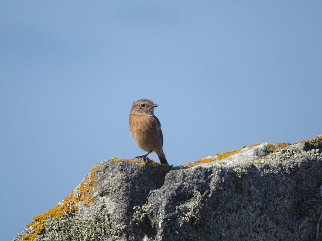 for sale on that island and the bird is a Stonechat. The male has a black head and this is the female. I love the lichen on the granite too.
Last edited: 03 October 2016 12:17:13
They're beautiful little birds GD. I love the lichens on rocks too. I took a pic on my way yesterday of a rock with a moss on it. I find all these things really interesting.
Yes - I was 'Mamore-ing' Joyce. I had planned to add on Binnein Beag to Sgurr Eilde Mor, which was my main focus, but it's a hell of a shift. You have to drop down such a long way into the corrie before going back up. I hadn't felt particularly well on Saturday, which is why I went yesterday. I'm glad I only did the one though as my knees were a bit iffy on the way back. I'll just have to schlepp back up another day to get the others
I'll organise my photos later. There were some nice ones. Nevis was completely clear, and you could see for miles.
I live in west central Scotland - not where that photo is...
Yesterday's walk to Sgurr Eilde Mor - the most easterly of the Mamores, on the south side of Glen Nevis.
The fog en route stopped me getting any shots of Rannoch Moor, but five minutes further on, the fog was lifting and I got a quick pic of the two Black Mount hills (Meall a Bhuiridh and Creise) just before Glencoe.
Looking south over Loch Eilde with the Glencoe hills behind
Looking west over Loch Leven - the two Munros of the Ballachulish Horseshoe at the back. Pap of Glencoe sitting in front of them
Sgurr Eilde Mor and it's lochan - almost big enough to be a loch...
Looking north from the same spot. Binnean Beag centre of pic. Behind it - the Grey Corries on the right, the Aonachs on the left
Pano of Binnein Mor (left of pic) across ridge to Binnein Beag
Holidaymakers getting a clear shot of Nevis
From the summit ridge - looking down onto the lochan and across to Sgurr Mor Beag (which leads to Binnein Mor) with Na Gruagaichean just peeking up behind it
Ben Nevis and it's arete Carn Mor Dearg. The ridge from Binnein Mor to Binnein Beag in the foreground
From the summit looking south over the Glencoe and Orchy hills, B. Mor on right
Binnein Mor from the little arete on Sgurr Eilde Mor
Pano of S. Eilde Mor and lochan on way back
View up to Am Bodach - another of the Mamores - on the way back down
Hope you enjoyed my jaunt to the beautiful Kinlochleven Mamores
I live in west central Scotland - not where that photo is...
The visibility was excellent for you Fairy. . . . a super day on the hills in a beautiful area
Wow Fairy! Jaunt? Looks like miles, how far did you walk?
Yes, I was just thinking that too B-L. Such a crisp, clear atmosphere up there - stunning again Fairy.
It was about 9 and a half miles in total, but it's not quite the same as low level walking. Just under 7 hours, including all the stops. A little over 5 hours actual walking. It's about another 2 - 3 hours to add the other hill on.
Pretty vertical for the final ascent from the lochan and it's all eroded, loose scree, so you have to scramble up. In the third last pic, you can see where you get onto the ridge - from the right hand side, just beyond that pile of rocks at the bottom . The summit's about 100 feet the other way. Two steps forward and a slide back when you get near the top though, so I took a detour and went round the end and up over it instead to get up, which was good fun
I live in west central Scotland - not where that photo is...
You're amazing Fairy. I can't imagine doing that. The weather must have been perfect. Photos are outstanding. Thanks again for sharing.
You're very kind ladies. Not that amazing when you get passed by all the younger, fitter people on the way.....
Veyr lucky with the weather. It wasperfect for walking - only a few degrees for the early part which makes it more pleasant, enough breeze to keep you cool but not too bad on the exposed bits. Clear skies so that you felt you could see forever. From the summit you feel that you can see almost every hill inthe Highlands and Cairngorms. Buzzards and bellowing stags. What more could a girl ask for
This chap had a pretty good view from the other end of the summit ridge too
I live in west central Scotland - not where that photo is...